This activity will be broken down into two parts. The
first will be an explanation of the importance of proper mission planning in
regards to data collection and the second will be a walkthrough of how
to set up a geodatabase with proper domains. Later the geodatabase that is created will be used to collect data on Microclimates here on the UWEC campus.
Part I - Proper Mission
Planning for Data Collection
Before heading out to the field to collect data, it
is crucial to fully understand what features are going to be collected and what
attributes about them should be stored. Data can be represented different ways
in a computer and each data type has its purposes and limitations.
Understanding this concept can help determine the best data type for whatever
features are being collected. Regardless of the specifics, it is always a good
idea to store the data in a file geodatabase. A file geodatabase is essentially
a system folder that reads and manages geospatial data. There are multiple
advantages to using a file geodatabase, which is best described by ESRI here.
There are six data types or field types available
when creating a file geodatabase; short integer, long integer, float, double,
text, and date. Taken from ArcGIS Desktop Help:
Data type
|
Storable range
|
Size (Bytes)
|
Applications
|
Short integer
|
-32,768 to 32,767
|
2
|
Numeric values without fractional
values within specific range; coded values
|
Long integer
|
-2,147,483,648 to 2,147,483,647
|
4
|
Numeric values without fractional
values within specific range
|
Float (single-precision
floating-point number)
|
approximately -3.4E38 to 1.2E38
|
4
|
Numeric values with fractional
values within specific range
|
Double (double-precision
floating-point number)
|
approximately -2.2E308 to 1.8E308
|
8
|
Numeric values with fractional
values within specific range
|
Data type: Text – the field will represent a series of alphabetic symbols.
The Text type is what you would expect, it enables the storage of words through
the use of written language.
Data type: Date – used to store dates and/or times. The default format is
mm/dd/yyy hh:mm:ss and a specification of AM or PM.
When deciding what numeric data type to use, it is best to
choose the type that will minimize storage space. If the values collected are
expected to range from 1 to 1,000, the short integer data type would be most
appropriate. If the values collected are expected to reach numbers that exceed
4 billion that Float would be most appropriate. Another consideration to make
is the precision of the data collected. Float will only store 6 decimal
positions while double will store 15.
After the data type is chosen
the domain type can be selected. There are two chocies for domain type: Range
and Coded Values. Each data type can be associated with either domain type
except for text, which requires Coded Values. Range lets the user define a
range of numbers that the data must fall within. This can help reduce user
input error. When creating a domain for temperature data, the user may want to
make the range 0-99 (for Fahrenheit) if they are confident that the temperature
will not be less than 0 or more than 99. That way when the user is collecting
data and accidentally adds an extra digit, entering 455 instead of 45, the data
will automatically be rejected minimizing confusion and effort later on when
analyzing the data. The next option is Coded Values. For this type, a numeric
or textual “code” can be attached to a more robust description. This is useful
for recording a simple cardinal direction of North, East, South, or West for
example. Instead of entering the full direction name for each sample, coded
values would allow just an “N” for North or “S” for South, minimizing collection
time and tediousness.
After the desired domains are
created, a feature class(es) can be made with descriptive fields. The fields
created will need to have a data type selected just like the domains. This data
type selection is important because it will determine the domains that are
available. Each field will be given a domain and multiple fields can have the
same domain. The fields are what will be used when the data is collected and
the domain attached to the field will determine the criteria the data will need
to fulfill.
Part II - Geodatabase
Creation
ArcCatalog will be used to create and modify the
geodatabase. To create a geodatabase right-click the destination folder, hover
the mouse over New, and choose File Geodatabase.

Figure 1: After creating a file geodatabase this is what the screen will look like.

Figure 2: Right click on the file geodatabase and choose properties. The Database Properties window will appear. The data type or field type can be chosen via the highlighted dropdown menu. Notice the six data types discussed earlier.
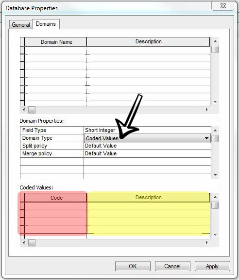
Figure 3: With the domain type as Coded Values, the red highlighted portion of the window is where the "code" is entered (N for North, 1 for Group 1, etc.) and the yellow highlighted portion is where a description of the code goes (North describes N, Group 1 describes 1, etc).

Figure 4: With the domain type as range, the maximum and minimum values can be entered in the red highlighted portion of the window.

Figure 5: Once the geodatabase and desired domains are created, a new feature class can be made. The type of features can be chosen from the drop down menu. Click next after naming the feature class and selected its type.

Figure 6: Next the coordinate system can be established or changed. Once the proper coordinate system is chosen click next. Click next on the next two windows that appear and the fields for the feature class can be created.

Figure 7: Type the name of the desired field in the Field Name section of the table. These names are what will be used in the field for data collection, so make these names recognizable and distinguishable. The arrow pointing at "Float" in the data type and the arrow pointing at Temp in the Domain dropdown box, show the relation between filed data type and available domains. The only domain with the Float data type is Temp and is therefore selectable with fields that also have the Float data type.

Figure 8: These are the final domains that were created for the future UWEC Microclimate survey. Group has a short integer data type with coded values (notice the values at the bottom of the window). Relative_Hum has a float data type with a range of 0 to 100 (because it is a percent). Snow_Dep has a float data type with a range of 0 to 36 (assumed max height of snow is a meter stick in inches). Temp has a float data type with a range of -20 to 99 (assuming temperature will not go below -20 degrees anymore and not over 99). Time has a short integer data type with a range of 0 to 2400 (for recording military time). Wind_Dir has a text data type with coded values (N = North, NE = Northeast, etc). Wind_Spd has a short integer data type with a range of 0 to 60 (assuming wind speeds will not exceed 60 mph)

Figure 9: These are the final fields created for the future UWEC Microclimate survey. Many of the fields have similar names to the domain they will be defined by. Besides those, Dew_Point will use the Temp domain and Notes has no domain. Notes will be used for entering any useful information in the field that may be good to know later on (such as noticeable anomalies, mistakes, etc.).
No comments:
Post a Comment